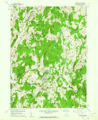
1960 Map of Millbrook
USGS Topo · Published 1962About this map
Millbrook and the surrounding Dutchess County countryside appear here in the early 1960s, defined by a landscape of institutional campuses, historic road networks, and scattered estates. The village is a significant educational and social hub, anchored by the sprawling Bennett College campus and the Dutchess Sch, while the County Home and St Josephs Sch sit nearby. The mapping reveals a transition from traditional agricultural land to more specialized uses, including a large Golf Course and several rural residential pockets like Millbrook Heights and Littlerest.
Find a feature on this map
42 named features on this map. Tap any name to fly to it.
Don’t see what you’re looking for? This feature index may not catch every label — zoom into the map to look around manually.
Map Details
Editions of this 1960 Millbrook Map
4 editions found
Other maps of this area

1893 · Clove
USGS Topo · 1:62,500

1893 · Poughkeepsie
USGS Topo · 1:62,500

1894 · Clove
USGS Topo · 1:62,500

1894 · Poughkeepsie
USGS Topo · 1:62,500

1898 · Clove
USGS Topo · 1:62,500

1898 · Rhinebeck
USGS Topo · 1:62,500

1899 · Millbrook
USGS Topo · 1:62,500

1901 · Clove
USGS Topo · 1:62,500

1902 · Millbrook
USGS Topo · 1:62,500

1903 · Poughkeepsie
USGS Topo · 1:62,500