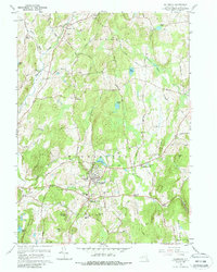
1960 Map of Millbrook
USGS Topo · Published 1988About this map
Millbrook and its neighboring hamlets define the character of central Dutchess County during the mid-20th century. The village centers of South Millbrook, Stanfordville, and Mabbettsville are connected by a network of rural routes like the Sharon Turnpike and Shunpike, reflecting the region's long history as a pastoral and residential hub. Educational and religious institutions are prominent landmarks, including the campus of Bennett College, St Josephs Sch, and the Dutchess Sch.
Find a feature on this map
80 named features on this map. Tap any name to fly to it.
Don’t see what you’re looking for? This feature index may not catch every label — zoom into the map to look around manually.
Map Details
Editions of this 1960 Millbrook Map
4 editions found
Other maps of this area

1893 · Clove
USGS Topo · 1:62,500

1893 · Poughkeepsie
USGS Topo · 1:62,500

1894 · Clove
USGS Topo · 1:62,500

1894 · Poughkeepsie
USGS Topo · 1:62,500

1898 · Clove
USGS Topo · 1:62,500

1898 · Rhinebeck
USGS Topo · 1:62,500

1899 · Millbrook
USGS Topo · 1:62,500

1901 · Clove
USGS Topo · 1:62,500

1902 · Millbrook
USGS Topo · 1:62,500

1903 · Poughkeepsie
USGS Topo · 1:62,500