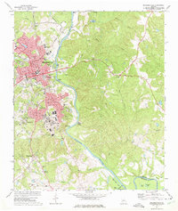
1972 Map of Milledgeville
USGS Topo · Published 1975About this map
The Oconee River flows through this Georgia landscape, defining the character of Milledgeville and its surrounding communities during the early 1970s. The map illustrates the town's role as an educational and institutional hub, featuring the sprawling campuses of Georgia College and Georgia Military College. Further south, the extensive complex of the State Hospital dominates the area around Hardwick, while the Central of Georgia railroad line cuts through the western terrain near Harrisburg.
Find a feature on this map
61 named features on this map. Tap any name to fly to it.
Don’t see what you’re looking for? This feature index may not catch every label — zoom into the map to look around manually.
Map Details
Editions of this 1972 Milledgeville Map
3 editions found
Other maps of this area

1912 · Milledgeville
USGS Topo · 1:62,500

1916 · Irwinton
USGS Topo · 1:62,500

1920 · Irwinton
USGS Topo · 1:62,500

1953 · Athens
USGS Topo · 1:250,000

1956 · Gordon
USGS Topo · 1:62,500

1957 · Macon
USGS Topo · 1:250,000

1958 · Macon
USGS Topo · 1:250,000

1958 · Athens
USGS Topo · 1:250,000

1959 · Athens
USGS Topo · 1:250,000

1963 · Athens
USGS Topo · 1:250,000