1912 Map of Milledgeville
USGS Topo · Published 1944About this map
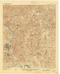
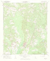
Milledgeville serves as the focal point of this 1909 survey, showcasing the city's complex rail infrastructure and the sprawling grounds of the State Sanitarium. The Oconee River carves through the western landscape, past Collins Island and Oconee Siding, while the Georgia RR and its Macon Branch provide critical connections to smaller outposts like Carrs Station and Devereux. The map reveals a deeply established network of rural community centers, from the industrial Coleman Mill to numerous educational and religious sites including Griffin Academy, Union Point School, and Island Creek Church. Moving south of the city, the landscape transitions into the smaller settlements of Harrisburg and Scottsboro, alongside several distinct water bodies like Reedy Creek Lake and Powell Lake that define the local drainage patterns near the Wilkinson County line.
Find a feature on this map
68 named features on this map. Tap any name to fly to it.
Don’t see what you’re looking for? This feature index may not catch every label — zoom into the map to look around manually.
Map Details
Editions of this 1912 Milledgeville Map
3 editions found
Other maps of this area
1912 · Milledgeville
USGS Topo · 1:62,500

1916 · Irwinton
USGS Topo · 1:62,500

1920 · Irwinton
USGS Topo · 1:62,500

1953 · Athens
USGS Topo · 1:250,000
1956 · Gordon
USGS Topo · 1:62,500

1957 · Macon
USGS Topo · 1:250,000

1958 · Macon
USGS Topo · 1:250,000

1958 · Athens
USGS Topo · 1:250,000

1959 · Athens
USGS Topo · 1:250,000
1961 · Deepstep
USGS Topo · 1:24,000