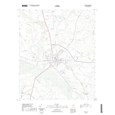
2020 Map of Millen
USGS Topo · Published 2020About this map
Millen serves as the focal point of this Jenkins County landscape, where the municipal grid is anchored by the Jenkins County Courthouse and defined by the path of Central of Georgia Ave. The town’s position just north of the Ogeechee River highlights its historical development as a rail and river crossroads. To the south and west, the terrain transitions into a complex of wetlands and waterways, including Buckhead Creek and Sculls Creek, which drain toward the primary river channel. Rural life is evidenced by small settlements like Lawton and Emmalane, along with family and community landmarks such as Little Buckhead Cem and Lane Cem. The map captures the subtle rises of Paramore Hill and Honey Ridge, illustrating how the agricultural and forested lands of east-central Georgia have been partitioned by a network of long-established roads like Old Louisville Rd and Sardis Rd.
Find a feature on this map
97 named features on this map. Tap any name to fly to it.
Don’t see what you’re looking for? This feature index may not catch every label — zoom into the map to look around manually.
Map Details
Editions of this 2020 Millen Map
This is the sole edition of this map. No revisions or reprints were ever made.
Other maps of this area

1920 · Millen
USGS Topo · 1:62,500

1921 · Rocky Ford
USGS Topo · 1:62,500

1943 · Rocky Ford
USGS Topo · 1:62,500

1943 · Millen
USGS Topo · 1:62,500

1943 · Millen
USGS Topo · 1:125,000

1947 · Savannah
USGS Topo · 1:250,000

1948 · Savannah
USGS Topo · 1:250,000

1957 · Macon
USGS Topo · 1:250,000

1957 · Savannah
USGS Topo · 1:250,000

1958 · Macon
USGS Topo · 1:250,000