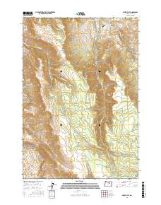
2017 Map of Miller Flat
USGS Topo · Published 2017About this map
The John Day Fossil Beds National Monument occupies the southwestern corner of this high-desert terrain, where drainage systems like McCarty Cr and Branson Cr carve through the landscape towards Devils Gulch. The central and eastern portions of the map are defined by the prominent Miller Flat and the rising slopes of Rudio Mtn, illustrating a region dominated by water management and natural springs. Multiple man-made catchments, including Waller Reservoir Number One and Waller Reservoir Number Three, suggest a landscape adapted for livestock or irrigation. This network of water sources, from Junction Springs to Burnt Corral Springs, highlights the critical importance of reliable water points in the arid environment of Grant County. Access to these areas is limited to a sparse network of mountain roads such as Holmes Creek Rd and Willow Creek Rd.
Find a feature on this map
37 named features on this map. Tap any name to fly to it.
Don’t see what you’re looking for? This feature index may not catch every label — zoom into the map to look around manually.
Map Details
Editions of this 2017 Miller Flat Map
This is the sole edition of this map. No revisions or reprints were ever made.
Other maps of this area

1951 · Courtrock
USGS Topo · 1:62,500

1951 · Monument
USGS Topo · 1:62,500

1953 · Kimberly
USGS Topo · 1:62,500

1953 · Picture
USGS Topo · 1:62,500

1955 · Canyon City
USGS Topo · 1:250,000

1959 · Canyon City
USGS Topo · 1:250,000

1980 · Monument
USGS Topo · 1:100,000
1990 · Monument
USGS Topo · 1:24,000
1990 · Miller Flat
USGS Topo · 1:24,000
1990 · Sheep Ridge
USGS Topo · 1:24,000