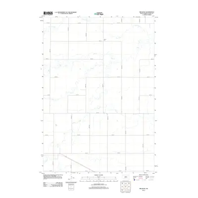
2012 Map of Miller SE
USGS Topo · Published 2012About this map
Beulah Cem stands as a lone memorial landmark in this rural Hand County landscape, situated just off 192nd St. The area is defined by a dense network of intermittent prairie waterways that drain the agricultural sections, most notably Turtle Cr and its northern tributary, Little Turtle Cr. These streams wind through a rigid grid of section-line roads, such as 370th Ave and 367th Ave, illustrating the intersection of natural drainage patterns with the systematic land surveys of the Great Plains. To the south, the headwaters of the Pearl Creek system appear, including Pearl Cr, E Pearl Cr, and W Pearl Cr. The absence of concentrated town centers emphasizes the persistent agricultural character of this region during the early 21st century.
Find a feature on this map
22 named features on this map. Tap any name to fly to it.
Don’t see what you’re looking for? This feature index may not catch every label — zoom into the map to look around manually.
Map Details
Editions of this 2012 Miller SE Map
This is the sole edition of this map. No revisions or reprints were ever made.
Other maps of this area

1899 · Redfield
USGS Topo · 1:125,000

1950 · Vayland
USGS Topo · 1:24,000

1950 · Wessington
USGS Topo · 1:24,000

1950 · Vayland NW
USGS Topo · 1:24,000

1953 · Huron
USGS Topo · 1:250,000

1954 · Huron
USGS Topo · 1:250,000

1966 · Burdette
USGS Topo · 1:24,000

1967 · Tulare NW
USGS Topo · 1:24,000

1967 · Miller
USGS Topo · 1:24,000
1967 · Miller SE
USGS Topo · 1:24,000