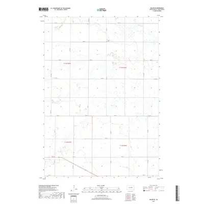
2017 Map of Miller SE
USGS Topo · Published 2017About this map
The rolling plains of Hand County are defined here by a series of intermittent prairie waterways, including Little Turtle Cr and Turtle Cr in the north and Pearl Cr and Ree Cr to the south. These drainage systems carve subtle paths through the township sections, reflecting the essential relationship between water and the South Dakota agricultural landscape. The isolated Beulah Cem sits along Co Rd 13, serving as a quiet focal point for local genealogy and a reminder of the early farming families who settled this region. The map’s strict section-line road network, comprised of routes like 193rd St and 367th Ave, underscores the enduring influence of the Public Land Survey System on the spatial organization of the Great Plains, where long stretches of gravel roads connect far-flung homesteads across the open horizon.
Find a feature on this map
24 named features on this map. Tap any name to fly to it.
Don’t see what you’re looking for? This feature index may not catch every label — zoom into the map to look around manually.
Map Details
Editions of this 2017 Miller SE Map
This is the sole edition of this map. No revisions or reprints were ever made.
Other maps of this area

1899 · Redfield
USGS Topo · 1:125,000

1950 · Vayland
USGS Topo · 1:24,000

1950 · Wessington
USGS Topo · 1:24,000

1950 · Vayland NW
USGS Topo · 1:24,000

1953 · Huron
USGS Topo · 1:250,000

1954 · Huron
USGS Topo · 1:250,000

1966 · Burdette
USGS Topo · 1:24,000

1967 · Tulare NW
USGS Topo · 1:24,000

1967 · Miller
USGS Topo · 1:24,000
1967 · Miller SE
USGS Topo · 1:24,000