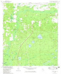
1982 Map of Millers Ferry
USGS Topo · Published 1983About this map
Holmes Creek meanders through the heart of this Florida landscape, defining a region rich with cypress ponds and small rural congregations. The settlement of Millers Ferry and nearby New Hope serve as the primary land-based anchors in an area where water profoundly shaped local life. Small community landmarks such as St Johns Ch and St Lukes Ch are scattered across the terrain, alongside family-named cemeteries including Weeks Cem and Dunn-Raley Cem. The influence of old industries is visible in labels like Mill Pond, Mill Branch, and Mill Lake, suggesting a history of local milling operations along the creek's tributaries. Numerous landings, such as Shell Landing and Spring Run Landing, indicate the importance of the river for transport and access in the late 1970s.
Find a feature on this map
60 named features on this map. Tap any name to fly to it.
Don’t see what you’re looking for? This feature index may not catch every label — zoom into the map to look around manually.
Map Details
Editions of this 1982 Millers Ferry Map
This is the sole edition of this map. No revisions or reprints were ever made.
Other maps of this area

1944 · Crystal Lake
USGS Topo · 1:24,000

1944 · Bruce
USGS Topo · 1:24,000

1945 · Red Head
USGS Topo · 1:31,680

1945 · Bruce
USGS Topo · 1:31,680

1945 · Crystal Lake
USGS Topo · 1:31,680

1948 · Ponce De Leon
USGS Topo · 1:24,000

1949 · Millers Ferry
USGS Topo · 1:24,000

1949 · Redbay
USGS Topo · 1:24,000

1949 · Hinsons Cross Roads
USGS Topo · 1:24,000

1950 · Millers Ferry
USGS Topo · 1:24,000