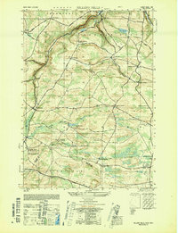
1949 Map of Millers Mills
USGS Topo · Published 1949About this map
Millers Mills serves as a central hub in this landscape where the headwaters of the Unadilla River and the waters of Unadilla Lake define the drainage of southern Herkimer County. The area is characterized by deep geographic fissures known as gulfs, including Beckus Gulf, Passage Gulf, and Polly Miller Gulf, which cut through the high ground of Columbia and Winfield townships. These natural formations dictated the placement of early infrastructure, from the winding path of Street Road to the strategic positioning of local reservoirs like Ilion Reservoir No 3.
Find a feature on this map
66 named features on this map. Tap any name to fly to it.
Don’t see what you’re looking for? This feature index may not catch every label — zoom into the map to look around manually.
Map Details
Editions of this 1949 Millers Mills Map
This is the sole edition of this map. No revisions or reprints were ever made.
Other maps of this area

1898 · Utica
USGS Topo · 1:62,500

1900 · Little Falls
USGS Topo · 1:62,500

1900 · Utica
USGS Topo · 1:62,500

1903 · Richfield Springs
USGS Topo · 1:62,500

1903 · Little Falls
USGS Topo · 1:62,500

1907 · Winfield
USGS Topo · 1:62,500

1939 · Little Falls
USGS Topo · 1:62,500

1943 · Schuyler Lake
USGS Topo · 1:24,000

1943 · Utica East
USGS Topo · 1:24,000

1943 · Jordanville
USGS Topo · 1:24,000