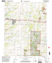
2000 Map of Millersburg
USGS Topo · Published 2002About this map
Cedar Creek and its many tributaries, including Little Cedar Creek and Salty Branch, define the rolling terrain of eastern Boone County at the turn of the millennium. This landscape is a patchwork of public conservation lands and rural crossroads, where the Mark Twain National Forest and Little Dixie State Wildlife Mgmt Area provide significant green space. The small settlements of Millersburg, Lindbergh, and Shaw serve as local anchors, connected by namesake paths like Vemers Ford Road and Bass Road. Social and family history is preserved through numerous rural landmarks, including the Simpson Chapel and several burial grounds like the Prairie Grove Cem and Hamilton Cem. While agriculture dominates, evidence of industry remains visible in the Strip Mines located near the Manacle Hills and the eastern edge of the survey area.
Find a feature on this map
37 named features on this map. Tap any name to fly to it.
Don’t see what you’re looking for? This feature index may not catch every label — zoom into the map to look around manually.
Map Details
Editions of this 2000 Millersburg Map
This is the sole edition of this map. No revisions or reprints were ever made.
Other maps of this area

1886 · Jefferson City
USGS Topo · 1:125,000

1890 · Moberly
USGS Topo · 1:125,000

1894 · Jefferson City
USGS Topo · 1:125,000

1917 · Sturgeon
USGS Topo · 1:62,500

1935 · Columbia
USGS Topo · 1:24,000

1940 · Columbia
USGS Topo · 1:24,000

1944 · Millersburg
USGS Topo · 1:62,500

1945 · Centralia
USGS Topo · 1:62,500

1946 · Millersburg
USGS Topo · 1:62,500

1947 · Jefferson City
USGS Topo · 1:250,000