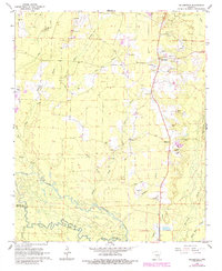
1964 Map of Millerville
USGS Topo · Published 1984About this map
The Saline River meanders across the southern portion of this landscape, forming the natural border between Grant and Dallas counties. This 1960s survey, updated in the early 1980s, reveals a rural economy heavily reliant on timber and mineral extraction, evidenced by the numerous Gravel Pits concentrated along the corridor of U.S. Route 167. The settlement at Millerville and the nearby Cross Roads serve as the primary hubs, while the backcountry is defined by a dense network of watercourses including Hurricane Creek, Tenmile Creek, and Lost Creek. Significant local genealogy interest is found in the scattered country churches and burial grounds, such as Shiloh Ch, Shiloh Cem, and Rhodes Cem. A Lookout Tower stands as a prominent landmark in the north, overseeing the forested terrain and the tributaries of the Saline River.
Find a feature on this map
26 named features on this map. Tap any name to fly to it.
Don’t see what you’re looking for? This feature index may not catch every label — zoom into the map to look around manually.
Map Details
Editions of this 1964 Millerville Map
3 editions found
Other maps of this area

1955 · Little Rock
USGS Topo · 1:250,000

1956 · Little Rock
USGS Topo · 1:250,000

1960 · Little Rock
USGS Topo · 1:250,000

1963 · Prattsville
USGS Topo · 1:24,000

1964 · Little Rock
USGS Topo · 1:250,000

1964 · Staves
USGS Topo · 1:24,000

1964 · Sheridan
USGS Topo · 1:24,000

1964 · Bunn
USGS Topo · 1:24,000
1964 · Millerville
USGS Topo · 1:24,000
1964 · Prague
USGS Topo · 1:24,000