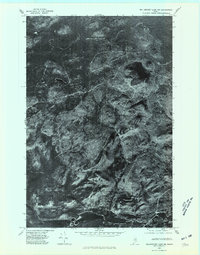
1975 Map of Millinocket Lake NW
USGS Topo · Published 1981About this map
Munsungan Lake anchors the southern edge of this orthophotoquad, showing the raw landscape of northern Piscataquis County in the mid-1970s. This specific type of survey uses rectified aerial photography rather than traditional line drawing, providing a direct visual of the dense forest cover and the network of logging tracks that cut across the terrain. High ground is defined by Mooseleuk Mountain in the northeast and the prominent rise of Willard Mountain further south, which transitions into the long spine of Willard Ridge. The imagery reveals the intensity of timber management in this era, with clear patterns of harvest and regrowth visible between the peaks and the shoreline, offering researchers a literal snapshot of Maine's industrial woodlands before modern conservation shifts.
Find a feature on this map
4 named features on this map. Tap any name to fly to it.
Don’t see what you’re looking for? This feature index may not catch every label — zoom into the map to look around manually.
Map Details
Editions of this 1975 Millinocket Lake NW Map
This is the sole edition of this map. No revisions or reprints were ever made.
Other maps of this area

1931 · Mooseleuk Lake
USGS Topo · 1:48,000

1932 · Musquacook Lakes
USGS Topo · 1:48,000

1935 · Musquacook Lakes
USGS Topo · 1:62,500

1935 · Mooseleuk Lake
USGS Topo · 1:62,500

1954 · Spider Lake
USGS Topo · 1:62,500

1954 · Millinocket Lake
USGS Topo · 1:62,500

1954 · Presque Isle
USGS Topo · 1:250,000

1958 · Presque Isle
USGS Topo · 1:250,000

1960 · Presque Isle
USGS Topo · 1:250,000

1961 · Spider Lake
USGS Topo · 1:62,500