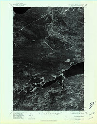
1975 Map of Millinocket Lake SW
USGS Topo · Published 1981About this map
Millinocket Lake dominates the southeastern portion of this 1975 orthophotoquad, its dark waters providing a sharp contrast to the dense timberland of the Maine woods. The orthophoto imagery, captured by the U.S. Geological Survey in October of that year, reveals the intricate texture of the forest floor and the web of logging roads that crisscross the terrain. Rising above the low-lying wetlands and smaller ponds is the prominent elevation of Caribou Ridge, which serves as a significant topographic landmark in this relatively uninhabited sector of Piscataquis County. This specialized map format prioritizes the raw aerial perspective over traditional cartographic symbols, allowing researchers to study the exact state of the shoreline and forest canopy before decades of subsequent growth and harvesting.
Find a feature on this map
2 named features on this map. Tap any name to fly to it.
Don’t see what you’re looking for? This feature index may not catch every label — zoom into the map to look around manually.
Map Details
Editions of this 1975 Millinocket Lake SW Map
This is the sole edition of this map. No revisions or reprints were ever made.
Other maps of this area

1953 · Telos Lake
USGS Topo · 1:62,500

1954 · Spider Lake
USGS Topo · 1:62,500

1954 · Millinocket Lake
USGS Topo · 1:62,500

1954 · Presque Isle
USGS Topo · 1:250,000

1955 · Traveler Mountain
USGS Topo · 1:62,500

1957 · Telos Lake
USGS Topo · 1:62,500

1958 · Presque Isle
USGS Topo · 1:250,000

1960 · Presque Isle
USGS Topo · 1:250,000

1961 · Spider Lake
USGS Topo · 1:62,500
1975 · Traveler Mountain NW
USGS Topo · 1:24,000