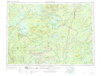
1954 Map of Millinocket
USGS Topo · Published 1975About this map
Mount Katahdin towers over the northern Maine wilderness in this mid-century portrait of the North Woods, a landscape defined by its timber heritage and emerging recreational identity. The Appalachian Trail winds through Baxter State Park and past dozens of remote water bodies including Pemadumcook Lake and Chesuncook Lake. In the mid-1950s, the industrial hubs of Millinocket and East Millinocket remain critical nodes where the West Branch Penobscot River met the transport capacity of the Bangor and Aroostook railroad.
Find a feature on this map
174 named features on this map. Tap any name to fly to it.
Don’t see what you’re looking for? This feature index may not catch every label — zoom into the map to look around manually.
Map Details
Editions of this 1954 Millinocket Map
3 editions found

Other maps of this area

1902 · Orono
USGS Topo · 1:62,500

1902 · Bangor
USGS Topo · 1:62,500

1903 · Bingham
USGS Topo · 1:62,500

1904 · Anson
USGS Topo · 1:62,500

1905 · Bingham
USGS Topo · 1:62,500

1905 · The Forks
USGS Topo · 1:62,500

1907 · The Forks
USGS Topo · 1:62,500

1913 · Skowhegan
USGS Topo · 1:62,500

1917 · Passadumkeag
USGS Topo · 1:62,500

1920 · Winn
USGS Topo · 1:62,500