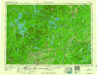
1960 Map of Millinocket
USGS Topo · Published 1960About this map
Mount Katahdin stands as the towering focal point of this mid-century landscape, anchoring the northern wilderness within Baxter State Park. The terrain is defined by a dense network of timber and water, where the West Branch Penobscot River flows through a chain of lakes including Pemadumcook Lake and Millinocket Lake. This era shows the region as a critical corridor for the logging industry and heavy rail, with the Canadian Pacific and Bangor and Aroostook railroads threading through the forest to reach junctions like Brownville Junction.
Find a feature on this map
309 named features on this map. Tap any name to fly to it.
Don’t see what you’re looking for? This feature index may not catch every label — zoom into the map to look around manually.
Map Details
Editions of this 1960 Millinocket Map
3 editions found

Other maps of this area

1902 · Orono
USGS Topo · 1:62,500

1902 · Bangor
USGS Topo · 1:62,500

1903 · Bingham
USGS Topo · 1:62,500

1904 · Anson
USGS Topo · 1:62,500

1905 · Bingham
USGS Topo · 1:62,500

1905 · The Forks
USGS Topo · 1:62,500

1907 · The Forks
USGS Topo · 1:62,500

1913 · Skowhegan
USGS Topo · 1:62,500

1917 · Passadumkeag
USGS Topo · 1:62,500

1920 · Winn
USGS Topo · 1:62,500