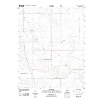
2011 Map of Mills East
USGS Topo · Published 2011About this map
The Kiowa National Grassland dominates this corner of Harding County, where the landscape is defined by the practical infrastructure of High Plains ranching. Settlement patterns here are represented by scattered homestead locations like Feltens, Fluhman, Bonomo, and Green, while the Mills Cemetery serves as a silent witness to the area's pioneer roots. The map reveals a reliance on groundwater and aviation, noted by several named windmills such as the Meikle Windmill and Freeman Windmill, alongside the Rigoni Landing Strips.
Find a feature on this map
28 named features on this map. Tap any name to fly to it.
Don’t see what you’re looking for? This feature index may not catch every label — zoom into the map to look around manually.
Map Details
Editions of this 2011 Mills East Map
This is the sole edition of this map. No revisions or reprints were ever made.
Other maps of this area

1954 · Santa Fe
USGS Topo · 1:250,000

1954 · Raton
USGS Topo · 1:250,000

1958 · Raton
USGS Topo · 1:250,000

1958 · Santa Fe
USGS Topo · 1:250,000

1971 · Abbott Lake
USGS Topo · 1:24,000

1971 · Beaver Canyon
USGS Topo · 1:24,000

1972 · Mills West
USGS Topo · 1:24,000
1974 · Roy
USGS Topo · 1:24,000
1974 · Kansas Valley
USGS Topo · 1:24,000
1974 · Kansas Valley Lake
USGS Topo · 1:24,000