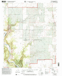
1998 Map of Mills West
USGS Topo · Published 2001About this map
The Kiowa National Grassland dominates this high plains landscape on the border of Mora and Harding Counties. The topography is defined by the dramatic descent into the Canadian River canyon system, where the river carves through the southwestern corner of the quadrangle. In the northern reaches, the broad Mesteñito Valley provides a contrast to the deep incisions of Cañon Vergere and Cañon Mesteño. Settlement remains sparse in this late-twentieth-century revision, centered on the small community of Mills and the isolated Cates Ranch. For genealogists and local historians, the Mesteñito Cem stands as a significant landmark of the area's earlier habitation. The map also records the infrastructure of the agricultural economy, including several Storage Bins and a network of pipelines and unimproved roads traversing the grassland.
Find a feature on this map
15 named features on this map. Tap any name to fly to it.
Don’t see what you’re looking for? This feature index may not catch every label — zoom into the map to look around manually.
Map Details
Editions of this 1998 Mills West Map
This is the sole edition of this map. No revisions or reprints were ever made.
Other maps of this area

1954 · Santa Fe
USGS Topo · 1:250,000

1954 · Raton
USGS Topo · 1:250,000

1958 · Raton
USGS Topo · 1:250,000

1958 · Santa Fe
USGS Topo · 1:250,000

1971 · Abbott Lake
USGS Topo · 1:24,000

1971 · Beaver Canyon
USGS Topo · 1:24,000

1971 · Canon Las Cuevas
USGS Topo · 1:24,000

1972 · Canon Colorado
USGS Topo · 1:24,000
1972 · Jaritas Ranch
USGS Topo · 1:24,000

1972 · Mills West
USGS Topo · 1:24,000