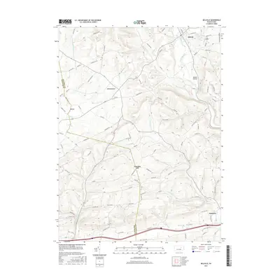
2016 Map of Millville
USGS Topo · Published 2016About this map
Millville stands as a primary hub within this central Pennsylvania landscape, where the waters of Little Fishing Creek and Spruce Run converge. The topography is defined by significant rises such as Ants Hill and Dodson Hill to the northwest, transitioning into the productive agricultural stretches of Greenwood Valley and Frosty Valley. The settlement pattern reflects a lineage of small rural communities connected by a dense network of secondary routes, including Eyers Grove, Jerseytown, and the high ground of Columbia Hill.
Find a feature on this map
92 named features on this map. Tap any name to fly to it.
Don’t see what you’re looking for? This feature index may not catch every label — zoom into the map to look around manually.
Map Details
Editions of this 2016 Millville Map
This is the sole edition of this map. No revisions or reprints were ever made.
Other maps of this area

1889 · Catawissa
USGS Topo · 1:62,500

1892 · Catawissa
USGS Topo · 1:62,500

1892 · Shamokin
USGS Topo · 1:62,500

1893 · Shamokin
USGS Topo · 1:62,500

1894 · Catawissa
USGS Topo · 1:62,500

1894 · Bloomsburg
USGS Topo · 1:62,500

1935 · Hughesville
USGS Topo · 1:62,500

1943 · Shamokin
USGS Topo · 1:62,500

1947 · Bloomsburg
USGS Topo · 1:24,000
1947 · Catawissa
USGS Topo · 1:24,000