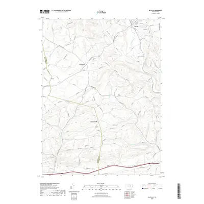
2019 Map of Millville
USGS Topo · Published 2019About this map
Millville and Jerseytown anchor this rural landscape along the border of Montour Co and Columbia Co, where the terrain is defined by the winding paths of Little Fishing Creek and Spruce Run. The settlement pattern reflects a deeply rooted community, evidenced by numerous burial grounds including Millville Cem, Jerseytown Cem, and the Millville Friends Cemetery, alongside the remote Dutch Hill Cem. Modern infrastructure like the Lake Airport near Valley View Lake sits in contrast to the traditional agricultural layouts of Derry and Eyers Grove. The map provides a detailed view of the regional drainage networks, tracing Mud Creek and the southern flow of Frozen Run toward Frosty Valley. Local road names often follow topographic landmarks, such as Hess Hill Road and Dodson Hill Road, which guide travelers through the upland ridges between the creek valleys.
Find a feature on this map
141 named features on this map. Tap any name to fly to it.
Don’t see what you’re looking for? This feature index may not catch every label — zoom into the map to look around manually.
Map Details
Editions of this 2019 Millville Map
This is the sole edition of this map. No revisions or reprints were ever made.
Other maps of this area

1889 · Catawissa
USGS Topo · 1:62,500

1892 · Catawissa
USGS Topo · 1:62,500

1892 · Shamokin
USGS Topo · 1:62,500

1893 · Shamokin
USGS Topo · 1:62,500

1894 · Catawissa
USGS Topo · 1:62,500

1894 · Bloomsburg
USGS Topo · 1:62,500

1935 · Hughesville
USGS Topo · 1:62,500

1943 · Shamokin
USGS Topo · 1:62,500

1947 · Bloomsburg
USGS Topo · 1:24,000
1947 · Catawissa
USGS Topo · 1:24,000