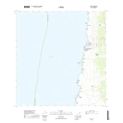
2017 Map of Milolii
USGS Topo · Published 2017About this map
Volcanic activity and coastal history define this stretch of the Island of Hawai‘i shoreline. The landscape is marked by the massive ‘Ālika Lava Flow of 1919 and the Ho‘ōpūloa Lava Flow of 1926, which permanently altered the topography near the settlement of Ho‘ōpūloa. Along the coast, the Ala Kahakai National Historic Trail traces a path through significant cultural and natural landmarks, connecting numerous bays and points. A series of small residential roads, such as Kai Ave and Waena Ave, appear north of Makahiki Point, showing modern subdivision patterns adjacent to the older lava fields. From Kīpahoehoe Bay in the north down to Niuou Point at the southern edge, the map documents a rugged interface where the Pacific Ocean meets the geologically recent additions to the island's landmass.
Find a feature on this map
53 named features on this map. Tap any name to fly to it.
Don’t see what you’re looking for? This feature index may not catch every label — zoom into the map to look around manually.
Map Details
Editions of this 2017 Milolii Map
This is the sole edition of this map. No revisions or reprints were ever made.
Other maps of this area

1928 · Hoopuloa
USGS Topo · 1:62,500

1954 · Hawaii South
USGS Topo · 1:250,000

1959 · Hawaii South
USGS Topo · 1:250,000

1961 · Hawaii South
USGS Topo · 1:250,000

1962 · Hawaii South
USGS Topo · 1:250,000

1962 · Milolii
USGS Topo · 1:24,000
1962 · Manuka Bay
USGS Topo · 1:24,000

1962 · Pohue Bay
USGS Topo · 1:24,000

1962 · Papa
USGS Topo · 1:24,000
1962 · Kauluoa Point
USGS Topo · 1:24,000