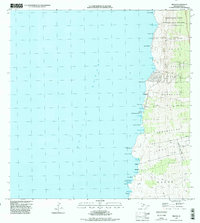
1996 Map of Milolii
USGS Topo · Published 1998About this map
Milolii remains a focal point on this coastal survey of the South Kona district, situated alongside its namesake Milolii Bay. The landscape is profoundly shaped by volcanic activity, with the massive Alika Lava Flow of 1919 and the Hoopuloa Lava Flow of 1926 visible as they scarred the terrain and reached the Pacific Ocean. These flows provide a stark timeline of the region's geological history, cutting through land divisions like Alika and Hoopuloa.
Find a feature on this map
44 named features on this map. Tap any name to fly to it.
Don’t see what you’re looking for? This feature index may not catch every label — zoom into the map to look around manually.
Map Details
Editions of this 1996 Milolii Map
This is the sole edition of this map. No revisions or reprints were ever made.
Other maps of this area

1928 · Hoopuloa
USGS Topo · 1:62,500

1954 · Hawaii South
USGS Topo · 1:250,000

1959 · Hawaii South
USGS Topo · 1:250,000

1961 · Hawaii South
USGS Topo · 1:250,000

1962 · Hawaii South
USGS Topo · 1:250,000

1962 · Milolii
USGS Topo · 1:24,000
1962 · Manuka Bay
USGS Topo · 1:24,000

1962 · Pohue Bay
USGS Topo · 1:24,000

1962 · Papa
USGS Topo · 1:24,000
1962 · Kauluoa Point
USGS Topo · 1:24,000