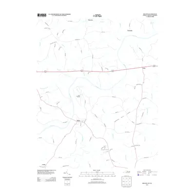
2013 Map of Milton
USGS Topo · Published 2013About this map
The Dan River winds across this borderland landscape between North Carolina and Virginia, framing the historic settlement of Milton. This 2013 survey documents a region defined by its rural road network and river crossings, where family-named landmarks like Brandon Chapel Rd and Sandy Creek Church Rd indicate deep-rooted community foundations. The northern portion of the map is dominated by the Virginia International Raceway, a significant modern landmark that stands in contrast to the traditional agricultural settlements of Sutherlin, Barksdale, and Delila. Smaller hamlets such as Dotmond and Estelle appear in the southern reaches, connected by winding routes like New Haven Rd. The map provides a precise look at the hydrology of the area, featuring tributaries such as Coquade Cr, Sandy Cr, and the boundary-marking Country Line Cr.
Find a feature on this map
74 named features on this map. Tap any name to fly to it.
Don’t see what you’re looking for? This feature index may not catch every label — zoom into the map to look around manually.
Map Details
Editions of this 2013 Milton Map
This is the sole edition of this map. No revisions or reprints were ever made.
Other maps of this area

1923 · Danville
USGS Topo · 1:48,000

1925 · Danville
USGS Topo · 1:62,500

1952 · Milton
USGS Topo · 1:62,500

1953 · Greensboro
USGS Topo · 1:250,000

1954 · Greensboro
USGS Topo · 1:250,000

1956 · Milton
USGS Topo · 1:62,500

1962 · Greensboro
USGS Topo · 1:250,000
1964 · Blairs
USGS Topo · 1:24,000

1965 · Ringgold
USGS Topo · 1:24,000

1966 · Greensboro
USGS Topo · 1:250,000