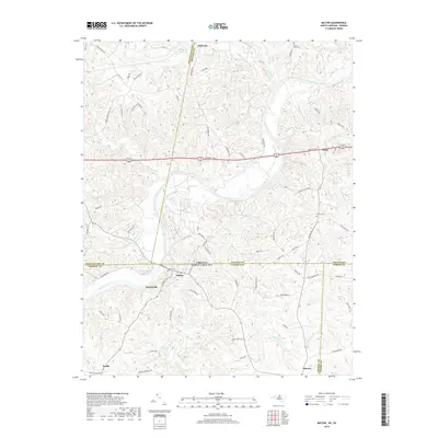
2019 Map of Milton
USGS Topo · Published 2019About this map
The Dan River winds through the heart of this borderland survey, marking the historic boundary between North Carolina and Virginia. The settlement of Milton serves as a focal point near the state line, positioned where the river valley meets the rolling landscape of Caswell County. Further south, the community of Yanceyville anchors the local geography, while the smaller hamlets of Estelle and Semora are situated along the southern reaches of Country Line Creek. This area's rural character is defined by a dense network of country roads such as Rocksprings Rd and Philpott Rd that connect family homesteads and local landmarks. Genealogists will find several burial grounds noted, including Mercy Seat Cem near the northern edge and Cedars Cem in the vicinity of Milton. The presence of Sutherlin Millpond and several significant tributaries like Cocquade Cr reflects the long-standing importance of water resources to the agricultural and milling history of these border counties.
Find a feature on this map
82 named features on this map. Tap any name to fly to it.
Don’t see what you’re looking for? This feature index may not catch every label — zoom into the map to look around manually.
Map Details
Editions of this 2019 Milton Map
This is the sole edition of this map. No revisions or reprints were ever made.
Other maps of this area

1923 · Danville
USGS Topo · 1:48,000

1925 · Danville
USGS Topo · 1:62,500

1952 · Milton
USGS Topo · 1:62,500

1953 · Greensboro
USGS Topo · 1:250,000

1954 · Greensboro
USGS Topo · 1:250,000

1956 · Milton
USGS Topo · 1:62,500

1962 · Greensboro
USGS Topo · 1:250,000
1964 · Blairs
USGS Topo · 1:24,000

1965 · Ringgold
USGS Topo · 1:24,000

1966 · Greensboro
USGS Topo · 1:250,000