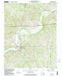
1997 Map of Milton
USGS Topo · Published 2000About this map
The Dan River meanders across the border of North Carolina and Virginia, defining the agricultural and historical landscape of this borderland region. In Caswell County, the town of Milton serves as a focal point near the river's edge, while smaller settlements like Sutherlin and Semora are connected by a network of rural roads and creek crossings. The map reveals a community deeply rooted in its religious and educational infrastructure, featuring numerous rural houses of worship such as White Stone Ch and New Haven Ch, alongside the New Dotmond Sch.
Find a feature on this map
37 named features on this map. Tap any name to fly to it.
Don’t see what you’re looking for? This feature index may not catch every label — zoom into the map to look around manually.
Map Details
Editions of this 1997 Milton Map
This is the sole edition of this map. No revisions or reprints were ever made.
Other maps of this area

1923 · Danville
USGS Topo · 1:48,000

1925 · Danville
USGS Topo · 1:62,500

1952 · Milton
USGS Topo · 1:62,500

1953 · Greensboro
USGS Topo · 1:250,000

1954 · Greensboro
USGS Topo · 1:250,000

1956 · Milton
USGS Topo · 1:62,500

1962 · Greensboro
USGS Topo · 1:250,000
1964 · Blairs
USGS Topo · 1:24,000

1965 · Ringgold
USGS Topo · 1:24,000

1966 · Greensboro
USGS Topo · 1:250,000