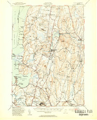
1948 Map of Milton
USGS Topo · Published 1954About this map
Fort Ethan Allen Military Res anchors the southern portion of this landscape, a significant post-war presence in the valley between the Winooski River and Malletts Bay. The terrain transitions from the low-lying shoreline of Lake Champlain, marked by numerous seasonal camps like Camp Rich and Camp Watson, to the rising elevations of Arrowhead Mountain and Georgia Mountain. The Central Vermont railroad line serves as a spine for the interior, connecting dairy-rich settlements like Milton and Georgia Center. Evidence of early community life is found in the scattered one-room schoolhouses, such as Silvertown Sch and Plain Sch, and the prominence of the Fairfax Bellows Academy. The presence of a Windmill near Town Corner Sch and several sawmills suggests a rural economy still tied to local resource processing and agriculture in the late 1940s.
Find a feature on this map
115 named features on this map. Tap any name to fly to it.
Don’t see what you’re looking for? This feature index may not catch every label — zoom into the map to look around manually.
Map Details
Editions of this 1948 Milton Map
4 editions found
Other maps of this area

1894 · Plattsburg
USGS Topo · 1:62,500

1895 · Rouse Point
USGS Topo · 1:62,500

1895 · Willsboro
USGS Topo · 1:62,500

1906 · Plattsburg
USGS Topo · 1:62,500

1906 · Burlington
USGS Topo · 1:62,500

1907 · Rouse Point
USGS Topo · 1:62,500

1913 · Milton
USGS Topo · 1:48,000

1914 · St. Albans
USGS Topo · 1:48,000

1915 · Milton
USGS Topo · 1:62,500

1916 · St. Albans
USGS Topo · 1:62,500