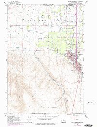
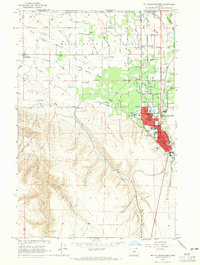
1964 Map of Milton-Freewater
USGS Topo · Published 1978About this map
The Little Walla Walla River and Walla Walla River branches define this productive agricultural corridor at the base of the Blue Mountain foothills. The landscape is characterized by an extensive network of irrigation and drainage features, including the Hudson Bay Canal and several gravel pits, supporting the region's long-standing orchard and farming economy. In the northern reaches, the Walla Walla Valley transitions into the hills where the Union Pacific railroad tracks follow the course of Dry Creek.
Find a feature on this map
64 named features on this map. Tap any name to fly to it.
Don’t see what you’re looking for? This feature index may not catch every label — zoom into the map to look around manually.
Map Details
Editions of this 1964 Milton-Freewater Map
2 editions found
Other maps of this area

1915 · Wallulah
USGS Topo · 1:96,000

1918 · Wallula
USGS Topo · 1:125,000

1919 · Walla Walla
USGS Topo · 1:125,000

1921 · Walla Walla
USGS Topo · 1:125,000

1935 · Pendleton
USGS Topo · 1:125,000

1953 · Pendleton
USGS Topo · 1:250,000

1953 · Walla Walla
USGS Topo · 1:250,000

1956 · Pendleton
USGS Topo · 1:250,000

1958 · Walla Walla
USGS Topo · 1:250,000
1964 · Milton-Freewater
USGS Topo · 1:24,000