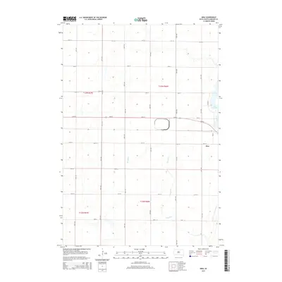
2015 Map of Mina
USGS Topo · Published 2015About this map
Mina anchors the eastern portion of this 2015 survey, situated just south of the recreational waters of Lake Parmley. The settlement’s grid is defined by Main St and 135th St, while the surrounding landscape reflects the organized agricultural divisions of Edmunds County. The drainage patterns of Stony Run wind through the southern sections of the quadrangle, highlighting the natural prairie hydrology of the region. This modern topographic record captures the transition from the small rural center to the outlying farmsteads, showing the enduring reliance on the section line road network, including thoroughfares such as 370th Ave and 134th St.
Find a feature on this map
23 named features on this map. Tap any name to fly to it.
Don’t see what you’re looking for? This feature index may not catch every label — zoom into the map to look around manually.
Map Details
Editions of this 2015 Mina Map
This is the sole edition of this map. No revisions or reprints were ever made.
Other maps of this area

1899 · Ellendale
USGS Topo · 1:125,000

1899 · Northville
USGS Topo · 1:125,000

1954 · Aberdeen
USGS Topo · 1:250,000

1956 · Aberdeen
USGS Topo · 1:250,000

1970 · Lake Parmley
USGS Topo · 1:24,000

1970 · Mina SW
USGS Topo · 1:24,000
1970 · Lake Parmley SW
USGS Topo · 1:24,000

1970 · Wetonka South
USGS Topo · 1:24,000

1970 · Mina NW
USGS Topo · 1:24,000
1970 · Richmond SW
USGS Topo · 1:24,000