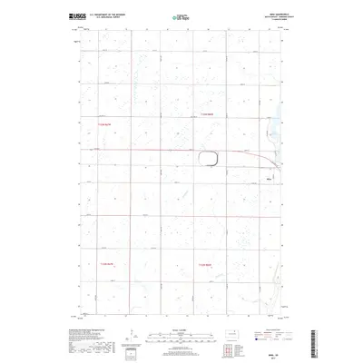
2017 Map of Mina
USGS Topo · Published 2017About this map
Mina and its surrounding agricultural landscape appear in this 2017 study of Edmunds County, showing a township structure defined by a strict section-line road grid. The settlement of Mina is positioned at the intersection of Main St and Co Rd 17, while the eastern portion of the map is dominated by the waters of Lake Parmley. This reservoir area is serviced by localized roads like W Lake Dr, reflecting the residential and recreational development adjacent to the water. The drainage of Stony Run meanders across the southern sections, providing a natural contrast to the geometric precision of the township range lines like t123n r67w and t122n r66w. Transport history is preserved through the marking of Old Hwy 12, which runs parallel to modern thoroughfares like 134th St, tracing the evolution of regional connectivity through the South Dakota prairie.
Find a feature on this map
27 named features on this map. Tap any name to fly to it.
Don’t see what you’re looking for? This feature index may not catch every label — zoom into the map to look around manually.
Map Details
Editions of this 2017 Mina Map
This is the sole edition of this map. No revisions or reprints were ever made.
Other maps of this area

1899 · Ellendale
USGS Topo · 1:125,000

1899 · Northville
USGS Topo · 1:125,000

1954 · Aberdeen
USGS Topo · 1:250,000

1956 · Aberdeen
USGS Topo · 1:250,000

1970 · Lake Parmley
USGS Topo · 1:24,000

1970 · Mina SW
USGS Topo · 1:24,000
1970 · Lake Parmley SW
USGS Topo · 1:24,000

1970 · Wetonka South
USGS Topo · 1:24,000

1970 · Mina NW
USGS Topo · 1:24,000
1970 · Richmond SW
USGS Topo · 1:24,000