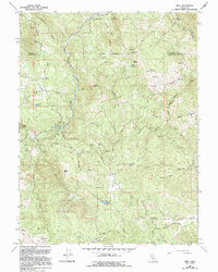
1967 Map of Mina
USGS Topo · Published 1994About this map
Mina and the northern reaches of the Round Valley Indian Reservation dominate this mid-20th-century survey of the Mendocino and Trinity county border. The landscape is defined by the deep drainage of the North Fork Eel River, which flows through the center of the quadrangle, joined by tributaries such as Hulls Creek and Horse Creek. Small, high-altitude water bodies including Who Who Lake, Gravelly Lake, and Lawrey Lake are scattered across the high country, providing water sources in a region characterized by prominent peaks like Wildhorse Peak and Bald Mountain.
Find a feature on this map
42 named features on this map. Tap any name to fly to it.
Don’t see what you’re looking for? This feature index may not catch every label — zoom into the map to look around manually.
Map Details
Editions of this 1967 Mina Map
2 editions found
Other maps of this area

1920 · Covelo
USGS Topo · 1:62,500

1921 · Hoaglin
USGS Topo · 1:62,500

1922 · Island Mountain
USGS Topo · 1:62,500

1926 · Covelo
USGS Topo · 1:62,500

1931 · Hoaglin
USGS Topo · 1:96,000

1935 · Hoaglin
USGS Topo · 1:125,000

1952 · Spyrock
USGS Topo · 1:62,500

1952 · Covelo
USGS Topo · 1:62,500

1953 · Blackrock Mtn
USGS Topo · 1:62,500

1954 · Blackrock Mtn
USGS Topo · 1:62,500