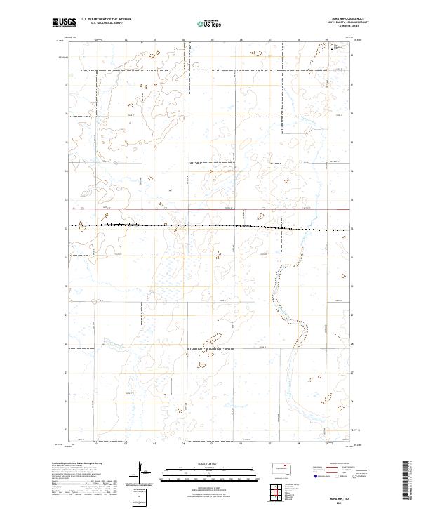
2021 Map of Mina NW
USGS Topo · Published 2021About this map
Craven serves as a central point on this modern South Dakota landscape, situated along the rail line that transects the northern plains of Edmunds County. The terrain is defined by the subtle drainage patterns of Preachers Run and the N Fork Snake Cr, which wind through a patchwork of agricultural sections and township boundaries. For those researching local family history, the presence of the New Straasburg Cem in the northeastern corner of the map provides a specific point of reference for early German-Russian or regional settlement patterns. The road network, including the path of Old Hwy 12 and various section-line roads like Co Rd 22, reflects the enduring rural infrastructure that has supported this prairie community for generations.
Find a feature on this map
25 named features on this map. Tap any name to fly to it.
Don’t see what you’re looking for? This feature index may not catch every label — zoom into the map to look around manually.
Map Details
Editions of this 2021 Mina NW Map
This is the sole edition of this map. No revisions or reprints were ever made.
Other maps of this area

1899 · Ellendale
USGS Topo · 1:125,000

1899 · Northville
USGS Topo · 1:125,000

1954 · Aberdeen
USGS Topo · 1:250,000

1956 · Aberdeen
USGS Topo · 1:250,000

1970 · Mina SW
USGS Topo · 1:24,000

1970 · Wetonka South
USGS Topo · 1:24,000

1970 · Mina NW
USGS Topo · 1:24,000
1970 · Mina
USGS Topo · 1:24,000

1970 · Leola SW
USGS Topo · 1:24,000
1970 · Mina SE
USGS Topo · 1:24,000