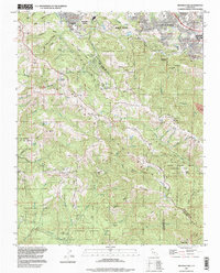
1997 Map of Mindego Hill
USGS Topo · Published 1999About this map
Santa Cruz Mountains terrain dominates this landscape south of Portola Valley, where steep ridges and deep gulches have historically limited dense development to the margins. The topography reveals a complex network of protected lands, including Portola State Park and Foothills Park, which preserve the watershed of numerous creeks like Pescadero Creek and Stevens Creek. One of the most distinctive cultural features is Coal Mine Ridge, a name that points to early resource extraction in an area now largely defined by its preservation and its proximity to the suburban growth of Los Altos Hills.
Find a feature on this map
65 named features on this map. Tap any name to fly to it.
Don’t see what you’re looking for? This feature index may not catch every label — zoom into the map to look around manually.
Map Details
Editions of this 1997 Mindego Hill Map
This is the sole edition of this map. No revisions or reprints were ever made.
Other maps of this area

1897 · Palo Alto
USGS Topo · 1:62,500

1899 · Palo Alto
USGS Topo · 1:62,500

1902 · Santa Cruz
USGS Topo · 1:125,000

1940 · Halfmoon Bay
USGS Topo · 1:62,500

1940 · Ano Nuevo
USGS Topo · 1:62,500

1941 · Ano Nuevo Pt.
USGS Topo · 1:62,500

1941 · Palo Alto
USGS Topo · 1:62,500

1942 · Ano Nuevo
USGS Topo · 1:62,500

1943 · Palo Alto
USGS Topo · 1:62,500

1943 · Halfmoon Bay
USGS Topo · 1:62,500