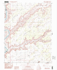
1996 Map of Mineral Canyon
USGS Topo · Published 2002About this map
The Green River carves a dramatic serpentine path through this canyon country, most notably at the sharp oxbow of Bowknot Bend. Along the river's banks, flat reaches like Spring Canyon Bottom, Mineral Bottom, and Tidwell Bottom provide rare level ground amidst the towering plateau edges of Deadman Point and Mineral Point. This 1996 photo-inspected survey captures the landscape as it appeared within the Canyonlands Nat Park boundaries, highlighting a network of 4wd tracks that offer the only access to this remote terrain. Traces of resource extraction are evident near the river at Mineral Canyon, where several Prospects and a Gravel Pit are recorded. The convergence of Hell Roaring Canyon and Roaring Canyon further illustrates the complex drainage systems that define the high desert topography between the Emery and Grand county lines.
Find a feature on this map
24 named features on this map. Tap any name to fly to it.
Don’t see what you’re looking for? This feature index may not catch every label — zoom into the map to look around manually.
Map Details
Editions of this 1996 Mineral Canyon Map
This is the sole edition of this map. No revisions or reprints were ever made.
Other maps of this area

1885 · San Rafael
USGS Topo · 1:250,000

1885 · La Sal
USGS Topo · 1:250,000

1951 · The Knoll
USGS Topo · 1:62,500

1951 · Upheaval Dome
USGS Topo · 1:62,500

1952 · Tidwell 4 SE
USGS Topo · 1:24,000

1952 · Moab 3 NE
USGS Topo · 1:24,000

1952 · Carlisle 2 NW
USGS Topo · 1:24,000

1952 · Moab 3 SE
USGS Topo · 1:24,000

1952 · Carlisle 2 NE
USGS Topo · 1:24,000

1952 · Tidwell 4 NE
USGS Topo · 1:24,000