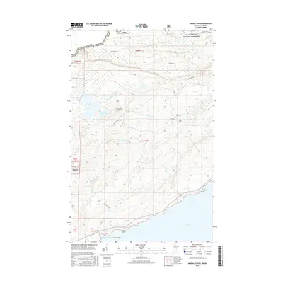
2016 Map of Mineral Center
USGS Topo · Published 2016About this map
The Pigeon River serves as the international boundary between Minnesota and Canada at the northern edge of this Cook County survey. The landscape is defined by the high elevations of Mt Sophie and Mt Maud, which overlook a network of water bodies including Swamp Lake and Speckled Trout Lake. To the east, the Grand Portage National Monument protects a large portion of the area's heritage, while the Superior National Forest encompasses the western timberlands. Local history is centered at the small settlement of Mineral Center, marked by the Mineral Center Cem. The southern reach of the map meets the cold waters of Lake Superior, where the shoreline is punctuated by Deronda Bay, Red Rock, and Blueberry Island. Historic travel ways like Old Hwy 61 and the Grand Portage Trl provide a look at the movement through this frontier-like terrain.
Find a feature on this map
41 named features on this map. Tap any name to fly to it.
Don’t see what you’re looking for? This feature index may not catch every label — zoom into the map to look around manually.
Map Details
Editions of this 2016 Mineral Center Map
This is the sole edition of this map. No revisions or reprints were ever made.
Other maps of this area

1958 · Hancock
USGS Topo · 1:250,000

1959 · Mineral Center
USGS Topo · 1:24,000

1959 · Fort William
USGS Topo · 1:250,000
1959 · Grand Portage
USGS Topo · 1:24,000

1960 · Hancock
USGS Topo · 1:250,000
1960 · The Cascades
USGS Topo · 1:24,000
1960 · Farquhar Peak
USGS Topo · 1:24,000
1960 · South Fowl Lake
USGS Topo · 1:24,000
1960 · Hovland
USGS Topo · 1:24,000

1961 · Hancock
USGS Topo · 1:250,000