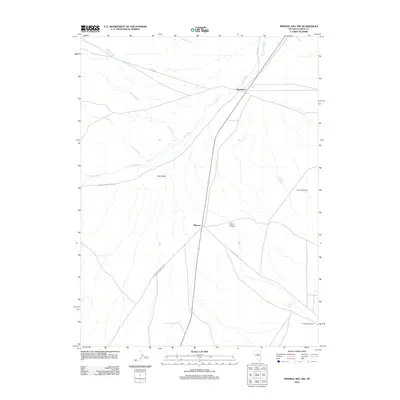
2012 Map of Mineral Hill NW
USGS Topo · Published 2012About this map
Pine Valley serves as the central corridor for this high-desert landscape in Eureka County, where the historic settlement of Mineral and the locality of Blackburn anchor a network of early ranching and mining routes. The map documents significant historical transit corridors, including the path from Knights Ranch to Pappys and the route from J D Ranch to Mineral Sta, which reflect the area's developmental reliance on connections between remote outposts and rail stations. Topographic features such as Aiken Canyon and Town Canyon define the eastern rise from the valley floor, while water sources like McCoy Spring and Willow Spring provide critical landmarks in an otherwise arid environment. The presence of Diamond Mine labels in the southern reaches highlights the mineral extraction history that gave the region its name.
Find a feature on this map
16 named features on this map. Tap any name to fly to it.
Don’t see what you’re looking for? This feature index may not catch every label — zoom into the map to look around manually.
Map Details
Editions of this 2012 Mineral Hill NW Map
This is the sole edition of this map. No revisions or reprints were ever made.
Other maps of this area

1937 · Mineral Hill
USGS Topo · 1:48,000

1943 · Mineral Hill
USGS Topo · 1:62,500

1952 · Pine Valley
USGS Topo · 1:62,500

1955 · Winnemucca
USGS Topo · 1:250,000

1957 · Frenchie Creek
USGS Topo · 1:62,500

1957 · Horse Creek Valley
USGS Topo · 1:62,500

1958 · Winnemucca
USGS Topo · 1:250,000

1962 · Winnemucca
USGS Topo · 1:250,000
1985 · Thatcher Spring
USGS Topo · 1:24,000
1985 · Coffin Mtn
USGS Topo · 1:24,000