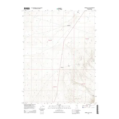
2014 Map of Mineral Hill NW
USGS Topo · Published 2014About this map
Pine Valley serves as the central geographic focus of this Eureka County landscape, where the high desert terrain is defined by a network of seasonal drainages and isolated springs. The small settlements of Blackburn and Mineral sit along the primary north-south corridor, linked by the route of State Highway 278. This 2014 survey documents the modern layout of these rural outposts and the surrounding ranching or mining lands before further development. The map detail highlights the importance of water sources in this arid environment, featuring named points like McCoy Spring and Willow Spring. Topographical features including Aiken Canyon and Town Canyon illustrate the complex drainage patterns feeding into Pine Cr, reflecting the long-standing geographic constraints on settlement and transit in the Nevada interior.
Find a feature on this map
17 named features on this map. Tap any name to fly to it.
Don’t see what you’re looking for? This feature index may not catch every label — zoom into the map to look around manually.
Map Details
Editions of this 2014 Mineral Hill NW Map
This is the sole edition of this map. No revisions or reprints were ever made.
Other maps of this area

1937 · Mineral Hill
USGS Topo · 1:48,000

1943 · Mineral Hill
USGS Topo · 1:62,500

1952 · Pine Valley
USGS Topo · 1:62,500

1955 · Winnemucca
USGS Topo · 1:250,000

1957 · Frenchie Creek
USGS Topo · 1:62,500

1957 · Horse Creek Valley
USGS Topo · 1:62,500

1958 · Winnemucca
USGS Topo · 1:250,000

1962 · Winnemucca
USGS Topo · 1:250,000
1985 · Thatcher Spring
USGS Topo · 1:24,000
1985 · Coffin Mtn
USGS Topo · 1:24,000