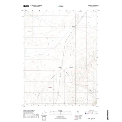
2018 Map of Mineral Hill NW
USGS Topo · Published 2018About this map
Pine Valley dominates this 2018 survey of Eureka County, Nevada, serving as a corridor for both water and transport. The small settlement of Blackburn sits along Pine Cr, while the named place Mineral lies further south, connected by the north-south arterial route. The landscape is defined by the transition from the valley floor to the rising elevations of Aiken Canyon and Cave Canyon to the east.
Find a feature on this map
18 named features on this map. Tap any name to fly to it.
Don’t see what you’re looking for? This feature index may not catch every label — zoom into the map to look around manually.
Map Details
Editions of this 2018 Mineral Hill NW Map
This is the sole edition of this map. No revisions or reprints were ever made.
Other maps of this area

1937 · Mineral Hill
USGS Topo · 1:48,000

1943 · Mineral Hill
USGS Topo · 1:62,500

1952 · Pine Valley
USGS Topo · 1:62,500

1955 · Winnemucca
USGS Topo · 1:250,000

1957 · Frenchie Creek
USGS Topo · 1:62,500

1957 · Horse Creek Valley
USGS Topo · 1:62,500

1958 · Winnemucca
USGS Topo · 1:250,000

1962 · Winnemucca
USGS Topo · 1:250,000
1985 · Thatcher Spring
USGS Topo · 1:24,000
1985 · Coffin Mtn
USGS Topo · 1:24,000