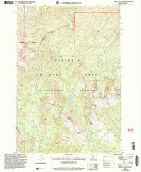
2000 Map of Mineral Mountain
USGS Topo · Published 2005About this map
Mineral Mountain towers over a landscape defined by the high-elevation drainages of the Gallatin National Forest. This high-country survey of the Absaroka Beartooth Wilderness documents a complex network of alpine water bodies and seasonal creeks, ranging from Arrastra Lake in the northwest to Charlie White Lake at the southern edge. The topography is etched by the West Fork Mill Creek and numerous tributaries like Gorge Creek and Cameron Creek, which reveal the glaciated character of the range. The boundary between the Livingston Gardiner Ranger District and surrounding wilderness areas reflects the administrative management of this protected backcountry at the turn of the twenty-first century. For researchers, the map provides a precise record of named natural features like Lonesome Pond and Thompson Lake, along with the specific corridors of the Wilderness Boundary.
Find a feature on this map
28 named features on this map. Tap any name to fly to it.
Don’t see what you’re looking for? This feature index may not catch every label — zoom into the map to look around manually.
Map Details
Editions of this 2000 Mineral Mountain Map
This is the sole edition of this map. No revisions or reprints were ever made.
Other maps of this area

1891 · Livingston
USGS Topo · 1:250,000

1893 · Livingston
USGS Topo · 1:250,000

1940 · Mt. Cowen
USGS Topo · 1:62,500

1940 · Mt Wallace
USGS Topo · 1:62,500

1943 · Mt Wallace
USGS Topo · 1:62,500

1943 · Mt Cowen
USGS Topo · 1:62,500

1947 · Bozeman
USGS Topo · 1:250,000

1948 · Bozeman
USGS Topo · 1:250,000

1955 · Bozeman
USGS Topo · 1:250,000

1955 · Emigrant
USGS Topo · 1:62,500