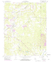
1958 Map of Mineral Point
USGS Topo · Published 1982About this map
Mineral Point and the surrounding mining district of Washington County are defined by an extensive extractive landscape of pits, tailings ponds, and rail spurs. The Missouri Pacific railroad serves as the central artery, connecting settlements like Cadet, Fountain Farm, and Hopewell. The area is notably dense with small family and community cemeteries, such as Brick Cem, Acquilla Cole Cem, and Westover Cem, which offer significant value for genealogical research in this part of Missouri.
Find a feature on this map
55 named features on this map. Tap any name to fly to it.
Don’t see what you’re looking for? This feature index may not catch every label — zoom into the map to look around manually.
Map Details
Editions of this 1958 Mineral Point Map
3 editions found
Other maps of this area

1901 · De Soto
USGS Topo · 1:125,000

1905 · Bonneterre
USGS Topo · 1:62,500

1906 · Potosi
USGS Topo · 1:62,500

1931 · De Soto SE
USGS Topo · 1:24,000

1937 · Tiff
USGS Topo · 1:24,000

1939 · Tiff
USGS Topo · 1:24,000

1946 · Richwoods
USGS Topo · 1:62,500

1948 · Richwoods
USGS Topo · 1:62,500

1949 · Saint Louis
USGS Topo · 1:250,000

1949 · Rolla
USGS Topo · 1:250,000