
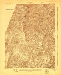
1923 Map of Mingo
USGS Topo · Published 1923About this map
The Lumber RR winds through the high ridges of the West Virginia mountains, tracing the rugged topography of the Elk River and Slaty Fork during a period of heavy timber extraction. This 1923 survey reveals a landscape organized around isolated hollows and high knobs, where small settlements like Mingo and Upper Mingo served as local hubs. The map is particularly detailed regarding rural infrastructure, documenting over a dozen schoolhouses including Swacker School, Hannah School, and Crooked Fork School. These community centers, alongside houses of worship like Marys Chapel and Poages Chapel, illustrate the social fabric of the Allegheny Highlands before modern road networks consolidated these mountain enclaves. Along the Tygart Valley River and its various forks, the map captures the transition from highland forests to the more settled Little Levels region near Edrey and Onoto.
Find a feature on this map
92 named features on this map. Tap any name to fly to it.
Don’t see what you’re looking for? This feature index may not catch every label — zoom into the map to look around manually.
Map Details
Editions of this 1923 Mingo Map
2 editions found
Other maps of this area

1889 · Beverly
USGS Topo · 1:125,000

1891 · Huntersville
USGS Topo · 1:125,000

1892 · Beverly
USGS Topo · 1:125,000

1893 · Buckhannon
USGS Topo · 1:125,000

1894 · Huntersville
USGS Topo · 1:125,000

1896 · Buckhannon
USGS Topo · 1:125,000

1897 · Buckhannon
USGS Topo · 1:125,000

1901 · Monterey
USGS Topo · 1:125,000

1913 · Hacker Valley
USGS Topo · 1:48,000

1913 · Pickens
USGS Topo · 1:48,000