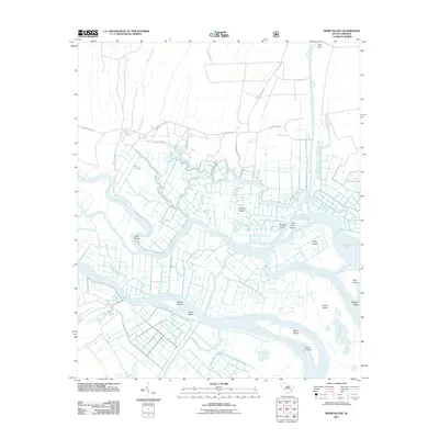
2011 Map of Minim Island
USGS Topo · Published 2011About this map
The North Santee River and South Santee River bifurcate this coastal landscape, creating a complex network of wetlands and islands. The delta's hydrology is further shaped by the Estherville-Minim-Creek-Canal and the Fourmile-Creek-Canal, reflecting historical and modern water management efforts in this marshy environment. Land access is restricted to a few established corridors like Annandale Rd and Santee Gun Club Rd, which lead toward the expansive North Santee Bay. Significant terrain features such as Minim Island, Kinloch Island, and Crow Island define the intricate waterways, while the South Island Ferry at the northern edge provides a critical transit link across the marsh. The naming conventions, including Old Kinloch Rd and Wicklow Hall Dr, suggest a landscape deeply tied to the historic plantation economy and managed waterfowl habitat characteristic of the South Carolina Lowcountry.
Find a feature on this map
42 named features on this map. Tap any name to fly to it.
Don’t see what you’re looking for? This feature index may not catch every label — zoom into the map to look around manually.
Map Details
Editions of this 2011 Minim Island Map
This is the sole edition of this map. No revisions or reprints were ever made.
Other maps of this area

1942 · Cape Romain
USGS Topo · 1:24,000

1942 · Mc Clellanville
USGS Topo · 1:24,000

1942 · Santee Point
USGS Topo · 1:24,000

1942 · North Island
USGS Topo · 1:24,000

1943 · Kilsock Bay
USGS Topo · 1:24,000

1943 · Santee
USGS Topo · 1:24,000

1943 · Minim Island
USGS Topo · 1:24,000

1943 · Georgetown South
USGS Topo · 1:24,000

1947 · Georgetown South
USGS Topo · 1:24,000

1949 · Georgetown
USGS Topo · 1:250,000