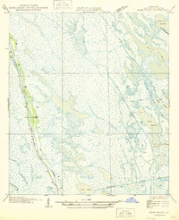
1946 Map of Mink Bayou
USGS Topo · Published 1946About this map
Bayou Lafourche anchors this coastal landscape, where the ribbon of State Highway No. 620 traces the high ground of the natural levee. In this mid-century environment, human presence is concentrated along this narrow corridor, marked by intermittent Cem sites and structures that represent the interface between the dry ridge and the surrounding wetlands. To the east and south, the terrain dissolves into an intricate network of open water and marshy passages, including the Southwestern Canal and Mink Bayou. This survey reveals the complex drainage patterns of the delta prior to extensive modern alterations, showing the reliance on natural waterways like Bayou Ferblanc and Bayou Pierre Et Lee for navigation and drainage. Shallow basins like Round Lake and Lake Jesse break the marsh, illustrating the fluid boundaries of the Louisiana coast.
Find a feature on this map
21 named features on this map. Tap any name to fly to it.
Don’t see what you’re looking for? This feature index may not catch every label — zoom into the map to look around manually.
Map Details
Editions of this 1946 Mink Bayou Map
This is the sole edition of this map. No revisions or reprints were ever made.
Other maps of this area

1892 · Cheniere Caminada
USGS Topo · 1:62,500

1892 · Creole
USGS Topo · 1:62,500

1894 · Timbalier
USGS Topo · 1:62,500

1894 · Lake Felicity
USGS Topo · 1:62,500

1935 · Bay Courant
USGS Topo · 1:31,680

1935 · Golden Meadow
USGS Topo · 1:31,680

1935 · Pelican Pass
USGS Topo · 1:31,680

1935 · Mink Bayou
USGS Topo · 1:31,680

1935 · Leeville
USGS Topo · 1:31,680

1939 · Lake Felicity
USGS Topo · 1:62,500