Old Maps of Leeville, Louisiana
Explore 16 old maps of Leeville, spanning from 1892 to today. These high-resolution historic maps reveal how streets, neighborhoods, landmarks, and natural features evolved over time — perfect for genealogy, metal detecting, research, and local history exploration.
What you can do with these maps:
- See how Leeville changed over time: Compare historical maps to modern-day views to trace roads, homesites, rail lines & more.
- View detailed metadata: Each map includes creators, publishers, year, scale, and archive source.
- Overlay maps with satellite & LiDAR: Visualize the past alongside modern tools to explore terrain & human change.
- Trusted historical sources: Maps sourced from the USGS, Library of Congress, and other archives.
- Access maps your way: View online, download high-res files, or order prints for personal or research use.
Start exploring old maps of Leeville to uncover forgotten places, hidden landmarks, and the deep history beneath your feet.
Leeville, LA maps
(16)- 1892 Map of Creole
 1892 Creole1892 Print · USGSCoastal Lafourche and Jefferson parishes appear in the early 1890s as a complex of tidal wetlands and prairies. Genealogists and historians can trace the original watercourses of Bayou Lafourche, Little Lake, and the remote Shrimp Ids.4 unique versions available
 - 1935 Map of Mink Bayou
 1935 Mink Bayou1935 Print · USGSCoastal Lafourche Parish in the mid-1930s shows a landscape of deep marshes and emerging bayous before the modern era of land loss. Researchers can trace historic family burial sites at Cem and explore the early path of State Highway No 620 alongside Bayou Lafourche.
 - 1945 Map of New Orleans
 1945 New Orleans1945 Print · USGSCoastal Louisiana and the Mississippi delta are captured here just after the war, showing the region's transition into a modern industrial and transit hub. Genealogists can trace family settlements along Bayou Teche or identify rail stops for the Illinois Central and Texas & Pacific lines.
 - 1946 Map of Mink Bayou
 1946 Mink Bayou1946 Print · USGSLafourche Parish during the mid-1940s reveals a coastal community defined by the narrow levee of Bayou Lafourche. Genealogists and historians can trace early settlements and roadside Cem locations along State Highway No. 620 and the banks of Mink Bayou.
 - 1954 Map of Mink Bayou
 1954 Mink Bayou1954 Print · USGSCoastal Lafourche Parish is captured here during the mid-1930s, showing the concentration of life along the narrow natural levees of the bayous. Genealogists can trace early homesteads and several Cem locations along Bayou Lafourche and State Highway No. 620.
 - 1957 Map of Mink Bayou, 1963 Print
 1957 Mink Bayou1963 Print · USGSThe coastal marshes of Lafourche Parish are captured here during a period of expanding energy infrastructure in the late fifties. You can trace the development of the Oil Field and Southwestern Canal alongside natural landmarks like Bay Rambo and Lake Jesse.3 unique versions available
 - 1963 Map of New Orleans
 1963 New Orleans1963 Print · USGSCoastal Louisiana in the mid-twentieth century reveals a complex world of bayou settlements, expanding oil fields, and vital rail networks. Genealogists and historians can trace family roots through river towns like Thibodaux or follow the Southern Pacific line through Franklin and Patterson.4 unique versions available
 - 1966 Map of New Orleans
 1966 New Orleans1966 Print · USGSCoastal Louisiana in the mid-1960s reveals a transition from traditional bayou life to an intensive offshore oil and gas economy. Researchers can trace the rail lines of the Southern Pacific RR through Morgan City or locate the Eugene Island Lighthouse among the delta's shifting marshes.
 - 1983 Map of Terrebonne Bay
 1983 Terrebonne Bay1983 Print · USGSThe Louisiana coast in the early 1980s reveals a labyrinth of bayous and barrier islands before decades of significant shoreline change. Researchers can trace the development of the energy industry and coastal settlements like Galliano and Montegut alongside the Isles Dernieres.
 - 1994 Map of Mink Bayou, 1995 Print
 1994 Mink Bayou1995 Print · USGSCoastal Louisiana in the mid-nineties is captured here as a landscape of industrial marshland and traditional bayou life. Genealogists and local historians can locate the Smith Mem Shrine and family landmarks like Griffith Cems or Cheramie Cem near the banks of Bayou Lafourche.
 - 1998 Map of Mink Bayou, 2001 Print
 1998 Mink Bayou2001 Print · USGSCoastal Lafourche Parish in the late nineties reveals a landscape of industrial energy production and marshland conservation. Researchers can trace family history through the Cheramie Cem or locate industrial sites like the Bayou Ferblanc Oil Field and the Leeville settlement.
 - 2012 Map of Mink Bayou, 2012 Print
 2012 Mink Bayou2012 Print · USGSCovers Leeville, including Lafourche Parish, United States, and other nearby areas
 - 2015 Map of Mink Bayou, 2015 Print
 2015 Mink Bayou2015 Print · USGSCovers Leeville, including Lafourche Parish, United States, and other nearby areas
 - 2018 Map of Mink Bayou, 2018 Print
 2018 Mink Bayou2018 Print · USGSCovers Leeville, including Lafourche Parish, United States, and other nearby areas
 - 2020 Map of Mink Bayou, 2020 Print
 2020 Mink Bayou2020 Print · USGSCovers Leeville, including Lafourche Parish, United States, and other nearby areas
 - 2024 Map of Mink Bayou, 2024 Print
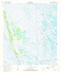
 2024 Mink Bayou2024 Print · USGSLafourche Parish is captured in the early twenty-first century, showing the critical intersection of modern infrastructure and marshland geography. Researchers can find Leeville Cem and trace historic routes like the Southwestern Louisiana Canal and Bayou Lafourche.
End of results
Showing maps 1-16 of 16
Top cities near Leeville
Frequently asked questions
- What are the different types of historical maps available for Leeville?
- What is the oldest map of Leeville?
- Where can I purchase historical maps of Leeville for my home or office?
- Where can I download high-res historical maps of Leeville?
- Are there historical topographic maps available for Leeville?
- Is there historical aerial imagery available for Leeville?
- Where are historical maps of Leeville sourced from?