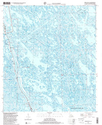
1998 Map of Mink Bayou
USGS Topo · Published 2001About this map
Leeville and its surrounding marshlands in Lafourche Parish are defined by an intricate network of waterways and heavy industrial activity at the close of the 20th century. The landscape is crisscrossed by numerous pipelines and extensive energy infrastructure, including the Bayou Ferblanc Oil Field and the Leeville Oil and Gas Field. This industrial presence is balanced against the conservation efforts seen in the Wisner Wildlife Management Area. Genealogists and local historians will find significant value in the documentation of family-named landmarks and burial sites, such as the Cheramie Cem and Griffith Cem, alongside the distinctive Smith Mem Shrine. The presence of a Floodgate and the transition of the marsh emphasize the ongoing struggle between human engineering and the shifting coastal environment of Bayou St Denis.
Find a feature on this map
14 named features on this map. Tap any name to fly to it.
Don’t see what you’re looking for? This feature index may not catch every label — zoom into the map to look around manually.
Map Details
Editions of this 1998 Mink Bayou Map
This is the sole edition of this map. No revisions or reprints were ever made.
Other maps of this area

1892 · Cheniere Caminada
USGS Topo · 1:62,500

1892 · Creole
USGS Topo · 1:62,500

1894 · Timbalier
USGS Topo · 1:62,500

1894 · Lake Felicity
USGS Topo · 1:62,500

1935 · Bay Courant
USGS Topo · 1:31,680

1935 · Golden Meadow
USGS Topo · 1:31,680

1935 · Pelican Pass
USGS Topo · 1:31,680

1935 · Mink Bayou
USGS Topo · 1:31,680

1935 · Leeville
USGS Topo · 1:31,680

1939 · Lake Felicity
USGS Topo · 1:62,500