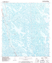
1994 Map of Mink Bayou
USGS Topo · Published 1995About this map
Bayou Lafourche serves as the central artery for this coastal landscape, where the terrestrial world gives way to an intricate network of wetlands and tidal waters. The settlement of Leeville is the primary human anchor, positioned where the bayou meets a vast system of oil and gas extraction zones. Industrial development is deeply integrated into the marsh, evidenced by the expansive Bayou Ferblanc Oil Field and Lake Enfermer Oil And Gas Field. Despite the industrial footprint, local heritage remains visible through landmarks like the Smith Mem Shrine and several family burial sites, including Griffith Cems and Cheramie Cem. The transition from open water to marsh is defined by named bodies such as Lake Jesse, Mink Bayou, and the broad expanse of Bay Jaque, illustrating the complex hydrology of southern Lafourche Parish.
Find a feature on this map
22 named features on this map. Tap any name to fly to it.
Don’t see what you’re looking for? This feature index may not catch every label — zoom into the map to look around manually.
Map Details
Editions of this 1994 Mink Bayou Map
This is the sole edition of this map. No revisions or reprints were ever made.
Other maps of this area

1892 · Cheniere Caminada
USGS Topo · 1:62,500

1892 · Creole
USGS Topo · 1:62,500

1894 · Timbalier
USGS Topo · 1:62,500

1894 · Lake Felicity
USGS Topo · 1:62,500

1935 · Bay Courant
USGS Topo · 1:31,680

1935 · Golden Meadow
USGS Topo · 1:31,680

1935 · Pelican Pass
USGS Topo · 1:31,680

1935 · Mink Bayou
USGS Topo · 1:31,680

1935 · Leeville
USGS Topo · 1:31,680

1939 · Lake Felicity
USGS Topo · 1:62,500