
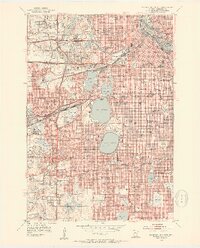
1952 Map of Minneapolis South
USGS Topo · Published 1954About this map
Minneapolis spreads across the eastern half of this survey, showcasing the city's celebrated chain of lakes and dense mid-century urban grid. The shoreline of Lake Calhoun and Lake Harriet are surrounded by public parklands like Lyndale Park and Beards Plaisance, illustrating the early 1950s commitment to recreational urban planning. Along the Mississippi River, the landscape is dominated by the Courthouse, Post Office, and a concentrated industrial corridor served by the Great Northern and other major rail lines.
Find a feature on this map
169 named features on this map. Tap any name to fly to it.
Don’t see what you’re looking for? This feature index may not catch every label — zoom into the map to look around manually.
Map Details
Editions of this 1952 Minneapolis South Map
2 editions found
Other maps of this area

1896 · Minneapolis
USGS Topo · 1:62,500

1896 · St. Paul
USGS Topo · 1:62,500

1901 · Minneapolis
USGS Topo · 1:62,500

1902 · White Bear
USGS Topo · 1:62,500

1902 · Anoka
USGS Topo · 1:62,500

1951 · St. Paul West
USGS Topo · 1:24,000

1951 · St. Paul SW
USGS Topo · 1:24,000

1951 · St. Paul
USGS Topo · 1:62,500

1952 · Minneapolis North
USGS Topo · 1:24,000

1952 · New Brighton
USGS Topo · 1:24,000