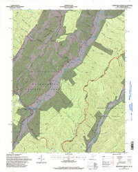
1995 Map of Minnehaha Springs
USGS Topo · Published 1998About this map
Minnehaha Springs and the surrounding wilderness of the Monongahela National Forest dominate this mid-1990s survey of the West Virginia and Virginia borderlands. The landscape is defined by the massive ridge of Browns Mountain and the winding course of Knapp Creek, which serves as a primary drainage for the numerous hollows such as Irvin Hollow and Hamilton Hollow. Along the waterway and nestled in the mountain gaps, small community anchors like Browns Creek Ch and Mt Carmel Ch appear alongside family-named burial sites including the Shinaberry Cem and McLaughlin Cem.
Find a feature on this map
92 named features on this map. Tap any name to fly to it.
Don’t see what you’re looking for? This feature index may not catch every label — zoom into the map to look around manually.
Map Details
Editions of this 1995 Minnehaha Springs Map
This is the sole edition of this map. No revisions or reprints were ever made.
Other maps of this area

1891 · Huntersville
USGS Topo · 1:125,000

1894 · Huntersville
USGS Topo · 1:125,000

1901 · Monterey
USGS Topo · 1:125,000

1922 · Cass
USGS Topo · 1:48,000

1923 · Marlinton
USGS Topo · 1:48,000

1923 · Warm Springs
USGS Topo · 1:48,000

1923 · Mingo
USGS Topo · 1:48,000

1924 · Cass
USGS Topo · 1:62,500

1925 · Mingo
USGS Topo · 1:62,500

1925 · Marlinton
USGS Topo · 1:62,500