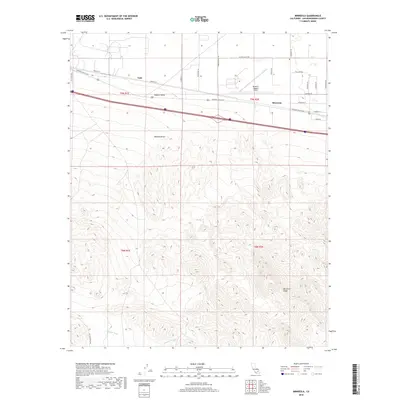
2018 Map of Minneola
USGS Topo · Published 2018About this map
Mojave Valley and the northern reaches of the Mojave Desert define this desert landscape, where transport infrastructure follows the natural east-west corridor of the basin. The small settlements of Gale and Minneola are situated along a historic transit route, now traced by the National Trails Hwy and Santa Fe St. To the south, the terrain rises sharply toward Minneola Ridge, a complex series of contours that overlook the seasonal drainage of Daggett Wash. The presence of the Barstow- Daggett Airport underscores the strategic importance of this open flatland for regional aviation. Grid-patterned local roads like Silver Valley Rd and Hidden Springs Rd provide access to the desert floor, reflecting the measured township and range surveying system that governs land division in San Bernardino County.
Find a feature on this map
29 named features on this map. Tap any name to fly to it.
Don’t see what you’re looking for? This feature index may not catch every label — zoom into the map to look around manually.
Map Details
Editions of this 2018 Minneola Map
This is the sole edition of this map. No revisions or reprints were ever made.
Other maps of this area

1953 · San Bernardino
USGS Topo · 1:250,000

1953 · Yermo
USGS Topo · 1:24,000
1953 · Nebo
USGS Topo · 1:24,000

1955 · Newberry
USGS Topo · 1:62,500

1955 · Ord Mountains
USGS Topo · 1:62,500

1955 · Rodman Mountains
USGS Topo · 1:62,500

1956 · San Bernardino
USGS Topo · 1:250,000

1956 · Daggett
USGS Topo · 1:62,500

1957 · San Bernardino
USGS Topo · 1:250,000

1958 · San Bernardino
USGS Topo · 1:250,000