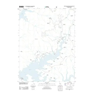
2012 Map of Minnesota Mountain
USGS Topo · Published 2012About this map
Shasta Lake dominates this northern California landscape, where the reservoir's intricate shoreline winds through a complex topography of ridges and canyons. The map centers on the northern reaches of the lake in Shasta County, highlighting recreational and historical points such as the Silverthorn Bay Resort and its Silverthorn Bay Boat Launching Ramp. The terrain is characterized by a series of named gulches and canyons, including Chain Gang Gulch and Dark Canyon, which drain from significant heights like Minnesota Mountain and Bully Hill. This geography reveals the relationship between the managed reservoir and the older landforms it flooded, with Monday Flat and various campgrounds like Dekkas Rock Campground and Rend Island Campground providing access points to the water's edge. This 2012 survey illustrates a landscape primarily shaped by timber access and recreation, with roads like Salt Creek Rd and Brock Mtn Lookout Rd providing the main overland transit through the dense drainages.
Find a feature on this map
52 named features on this map. Tap any name to fly to it.
Don’t see what you’re looking for? This feature index may not catch every label — zoom into the map to look around manually.
Map Details
Editions of this 2012 Minnesota Mountain Map
This is the sole edition of this map. No revisions or reprints were ever made.
Other maps of this area

1890 · Red Bluff
USGS Topo · 1:250,000

1894 · Red Bluff
USGS Topo · 1:250,000

1901 · Redding
USGS Topo · 1:125,000

1944 · Redding
USGS Topo · 1:62,500

1946 · Lamoine
USGS Topo · 1:62,500

1946 · Redding
USGS Topo · 1:62,500

1949 · Bollibokka Mtn
USGS Topo · 1:62,500

1953 · Millville
USGS Topo · 1:62,500
1957 · Project City
USGS Topo · 1:24,000
1957 · Lamoine
USGS Topo · 1:62,500