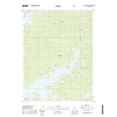
2021 Map of Minnesota Mountain
USGS Topo · Published 2021About this map
Bully Hill and Killanger Peak rise above the complex shoreline of Shasta Lake in this modern topographic study of northern California. The map documents the northern reaches of the reservoir where the McCloud River Arm, Squaw Creek Arm, and Pit River Arm converge. This area, managed as part of the Shasta National Forest, is defined by high ridgelines including Minnesota Mtn and Winnibulli Mtn, separated by deep drainage systems like Madison Canyon and Lick Canyon. The intricate hydrography shows how the rising waters of the lake have backfilled numerous gulches and canyons, creating a finger-like coastal pattern. While modern infrastructure is sparse, the presence of the Dekkas Trl and named flats such as Monday Flat indicate the area's continued use for recreation and forest management. Geographers can observe the rugged verticality of the landscape, from the peaks at Chirpchatter Mtn down to the submerged former river valleys.
Find a feature on this map
52 named features on this map. Tap any name to fly to it.
Don’t see what you’re looking for? This feature index may not catch every label — zoom into the map to look around manually.
Map Details
Editions of this 2021 Minnesota Mountain Map
This is the sole edition of this map. No revisions or reprints were ever made.
Other maps of this area

1890 · Red Bluff
USGS Topo · 1:250,000

1894 · Red Bluff
USGS Topo · 1:250,000

1901 · Redding
USGS Topo · 1:125,000

1944 · Redding
USGS Topo · 1:62,500

1946 · Lamoine
USGS Topo · 1:62,500

1946 · Redding
USGS Topo · 1:62,500

1949 · Bollibokka Mtn
USGS Topo · 1:62,500

1953 · Millville
USGS Topo · 1:62,500
1957 · Project City
USGS Topo · 1:24,000
1957 · Lamoine
USGS Topo · 1:62,500